
太遙中心 Center for Space & Remote Sensing Research
 Welcome to the Center for Space and Remote Sensing Research. This is one of the most mysterious departments on the huge campus. The first reason is because of its location, for it is quite far from other colleges and buildings. The second reason has to do with its delicate equipments; lots of students only know that the equipments are quite expensive but do not know what they are for.
The Center was established in 1984, thanks to the effort of our university president, Dr. Liu, who is a well-known scholar in the field of Space Sciences. As it was one of the later additions to the campus, there was not enough space for it in the center of the campus. So it was decided that it would be built in this far corner. The Center includes ten laboratories, all related to remote sensing and space science. It is the sole institution in Taiwan that provides such a broad and complete program in space science research and education, and it continuously participates in several international space research projects and collaborates with space science institutions of other countries.
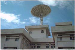
Among these ten labs, the one most closely related to the daily lives of the common people is the Meteorological Satellite Laboratory. It was established in 1992 and its main job is to receive, supply and apply meteorological satellite data. For us, that means our daily weather forecasts are based on data collected from the satellite sitting on top of this building. But I want to remind you that recent complaints about the inaccuracies of weather forecasts are a result of mis-readings by TV meteorologists, which has little to do with the researchers here.
Besides providing weather information for the common people, the Center and its data collection could be used in lots of different ways. Lots of businessmen and the military are clients of the Center. For the businessmen, those data could supply information for them to evaluate the economic potential and the distribution of natural resources. For the military, those data could be used as a tool to detect military activities of other countries. It makes me wonder if our university’s satellite has helped with American military actions in Afganistan. Now let’s move on.
Welcome to the Center for Space and Remote Sensing Research. This is one of the most mysterious departments on the huge campus. The first reason is because of its location, for it is quite far from other colleges and buildings. The second reason has to do with its delicate equipments; lots of students only know that the equipments are quite expensive but do not know what they are for. The Center was established in 1984, thanks to the effort of our university president, Dr. Liu, who is a well-known scholar in the field of Space Sciences. As it was one of the later additions to the campus, there was not enough space for it in the center of the campus. So it was decided that it would be built in this far corner. The Center includes ten laboratories, all related to remote sensing and space science. It is the sole institution in Taiwan that provides such a broad and complete program in space science research and education, and it continuously participates in several international space research projects and collaborates with space science institutions of other countries.
Among these ten labs, the one most closely related to the daily lives of the common people is the Meteorological Satellite Laboratory. It was established in 1992 and its main job is to receive, supply and apply meteorological satellite data. For us, that means our daily weather forecasts are based on data collected from the satellite sitting on top of this building. But I want to remind you that recent complaints about the inaccuracies of weather forecasts are a result of mis-readings by TV meteorologists, which has little to do with the researchers here.
Besides providing weather information for the common people, the Center and its data collection could be used in lots of different ways. Lots of businessmen and the military are clients of the Center. For the businessmen, those data could supply information for them to evaluate the economic potential and the distribution of natural resources. For the military, those data could be used as a tool to detect military activities of other countries. It makes me wonder if our university’s satellite has helped with American military actions in Afganistan. Now let’s move on.